Continental ecosystems monitoring
HYGEOS takes part in the Copernicus Land Monitoring Service from the beginning of the service operations in 2012. HYGEOS is the expert team for the definition of atmospheric corrections methods, applied in near real time, and validation of their performances. On one hand, SMAC_CL is used to retrieve Top-Of-Canopy (TOC) reflectances which are the common input to assess a set of vegetation parameters. On the other hand, Polymer is used to retrieve the lake surface reflectances which are the input to assess some water quality indices. Furthermore, HYGEOS coordinates the scientific activities of the consortium, led by VITO, in charge of the production of the global “Vegetation and Energy” variables. In particular, HYGEOS manages the evolution of portfolio, the validation of products and the communication towards users and other Copernicus actors.
Similarly, HYGEOS is involved in the Copernicus Climate Change Service from the beginning of the service operations in 2018. HYGEOS participates in the consortium in charge of the generation of long-term data records describing the evolution of some biosphere Essential Climate Variables (ECV). SMAC is used to perform the atmospheric correction with a focus on the propagation of uncertainties from Top-of-Atmosphere reflectance to the biophysical variables and taking into account multiple aerosol models and BRDF corrections.
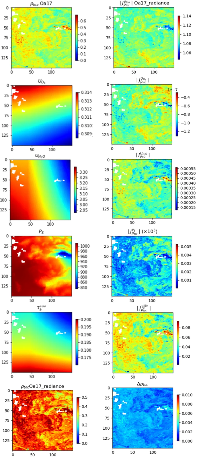
The atmospheric corrections benefit from the latest upgrades of the SMAC_CL code. In particular, the Jacobians allow calculating and propagating the part of the TOC reflectance uncertainty due to each key model parameter like the aerosol optical depth or the column of water vapor (example on the figure at right). The uncertainty due to the aerosol model is also taken into account.
The propagation of uncertainties, as well as the traceability along with the full processing chain, is a key topic of the FDR4VGT project. This project aims to generate a Fundamental Data Record of more than 20 years of land surface reflectance from SPOT/VEGETATION-1, -2 and PROBA-V observations. HYGEOS performs the atmospheric corrections with SMAC_CL where the FIDUCEO uncertainties propagation formalism is implemented.
Input TOA reflectances and interpolated auxiliary data (Ozone content, Water Vapour content, Pressure of Surface and Aerosol Optical Thickness at 550nm) from top to bottom (left column) and absolute values of their respective output Jacobians (right column), all in SMAC_CL units. The last row represents the resulting TOC reflectance (left) and its uncertainty (right).

Example for an area of about 45km x 45km centered on the AERONET station of Carpentras, France, extracted from Sentinel-3 OLCI spectral band at 865nm on 3rd of July 2018. White pixels are clouds.
Evolutions through research project
The evolutions of the Copernicus Climate Change Service are prepared through research projects like the ESA-funded Climate Change Initiative Vegetation Parameters project. This latter performs the necessary research and development needed for the generation of high quality, global, multi-mission time series of two vegetation ECVs (LAI and FAPAR), maximising the consistency between resolutions (1km and 300m) of different satellite missions and between different ECVs. Once again, SMAC_CL is used to perform the atmospheric correction on data of all satellite radiometers available during the period from 2000 to the present. HYGEOS assesses the performance of the atmospheric correction using the aerosol properties available in the AERONET dataset and the 6S accurate atmospheric correction method acting on Top-Of-Atmosphere reflectance extracted around AERONET sites that cover different biomes, locations and meteorological conditions. In this project, a particular attention is given to overlapping time period between several sensors in order to improve the multi-sensor consistency and to consolidate the error budget.

