

New PhD: ocean color retrieval from MetOP-SG
HYGEOS and the Laboratoire d’Optique Atmosphérique (LOA, University of Lille) have launched a new CIFRE PhD, supported by the French Association Nationale de la Recherche et de la Technologie (ANRT), to improve the observation of ocean color with Europe’s new MetOp-SG satellites.
The thesis is carried out by Pierre Posson, an ESTACA engineer who completed his final-year internship at HYGEOS. It is supervised by Jérôme Riedi (LOA) and François Steinmetz (HYGEOS), under the title: “Synergistic Atmospheric Corrections for Ocean Color Observation Using Multi-Angular Polarimetry from 3MI and the Spatial Resolution of METimage on Board MetOp-SG”.
Why ocean color matters
Seen from space, the color of the ocean reveals what the water contains: phytoplankton, sediments and dissolved organic matter. Phytoplankton feeds marine life and helps the ocean absorb CO₂. Monitoring it on a global scale is therefore essential to understand the carbon cycle and how the ocean responds to climate change.
Near the coast, these observations also help monitor water quality: river discharge, eutrophication, and algal blooms that can be harmful or toxic.
Satellites do not see the water directly. Between 80% and 95% of the light they measure comes from the atmosphere (molecules and aerosols) and from the sea surface, and the ocean signal is only a few percent of the total. Removing everything else is known as atmospheric correction. HYGEOS is a recognized expert in this field, with its Polymer algorithm used to process data from many ocean color sensors.
State of the art
The traditional approach estimates aerosols in the near-infrared, where the ocean is assumed to be black, and then extrapolates them to the visible. This assumption breaks down in turbid waters.
More generally, current methods rely only on color, observed from a single viewing angle. Measuring polarization from multiple angles provides independent information: it characterizes aerosols far more precisely and better separates the atmosphere from the ocean. The POLDER and PARASOL missions, followed by NASA’s PACE mission in 2024, have demonstrated this.
A unique opportunity with MetOp-SG
The European MetOp-SG platform, whose first satellite was launched in August 2025, brings together on a single satellite:
- the 3MI multi-angle polarimeter, rich in information but with kilometers-scale resolution;
- the METimage imager, with a resolution of 500 m;
- the Sentinel-5 spectrometer.
These instruments observe the same scene at the same time. The thesis aims to take advantage of this unique synergy: characterize aerosols with the multi-angle polarimetry of 3MI, then retrieve water reflectance at the high resolution of METimage. Sentinel-5 can complement the system by improving the detection of absorbing aerosols and colored dissolved organic matter (CDOM).
Expected results and first steps
The thesis will deliver a 3MI-METimage atmospheric correction algorithm, validated on real data and against in situ measurements. It will also quantify the actual benefit of polarization for ocean color.
The first correction studied since the start of the thesis in May 2026 addresses adjacency effects. Light reflected by nearby land contaminates the signal of water pixels close to the coast, and the problem becomes critical at high resolution and in high-contrast scenes. A machine learning correction, applied to simulated METimage scenes in coastal areas, was presented as a poster at Ocean Optics XXVII in September (see figure below).
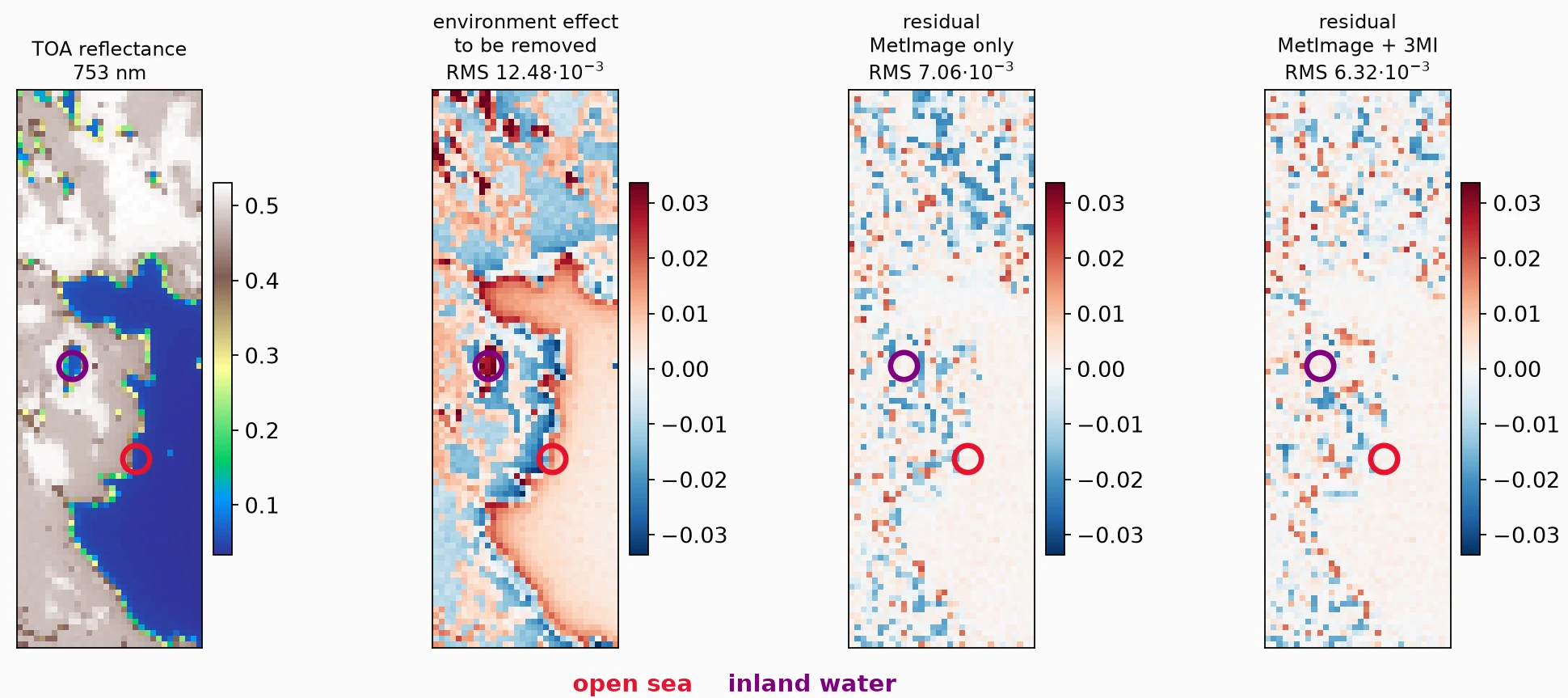
Full coastal scene corrected: 16 × 48 km – 753 nm. (a) TOA reflectance, (b) adjacency effect to be removed, (c) residual after correction with METimage inputs. (d) residual after correction with METimage+3MI inputs.