Detection of extreme atmospheric events
Context
The European operational observation of atmospheric composition from space currently benefits from data provided by the Infrared Atmospheric Sounding Interferometer (IASI) and the Global Ozone Monitoring Experiment-2 (GOME-2) flying on the Metop series of weather satellites, as well as the TROPOspheric Monitoring Instrument (TROPOMI) onboard the Sentinel-5P mission. These capacities will be extended and consolidated soon by the sensors of the Copernicus Sentinel-4 and Sentinel-5 missions, embarked on geostationary Meteosat Third Generation (MTG) and Metop-Second Generation (Metop-SG) platforms, respectively, operated by EUMETSAT. Then, in the next few years, hyperspectral sounding missions will deliver every day several terabytes of data representing an unprecedented amount of atmospheric data.
Deriving the concentration of several chemical species and, in some cases, their vertical distribution at the measurement location, i.e. at the instantaneous field of view (IFOV) of the sensor, allows to get the spatial patterns of gases concentration, their spatial distribution over the globe and to monitor their temporal evolution. Therefore, there is a great potential to detect and monitor strong pollution events: early detection over regions impacted by pollution due to mega fires, warning systems for high peaks of urban pollution, early warning and monitoring of volcanic eruption plumes, detection of high agricultural pollution or due to major industrial accident, … However, the exploitation of information about extreme atmospheric events is limited by the complexity of the physics and the large volume of data to process.
Consequently, one challenge is to develop capacities of intelligent screening of large amounts of satellite data for targeting scenes of interest in view of their specific processing or exploitation.
Activities
For many years now, HYGEOS and SPASCIA have developed together dedicated algorithms and tools, based on Principal Component Analysis (PCA) of Level 1 IASI spectra, for the systematic detection of fires, volcanoes, pollution plumes and other extreme atmospheric events. The detected extreme events are defined as outliers with respect to the representative global variability of the IASI spectra. Thus, the detection is driven by specific metric of the rarity of the spectrum behaviour. A number of indicators have been defined and optimized in order to discriminate the events according to their chemical composition. Those indicators are associated with detection thresholds, for “day” and “night” conditions. The ability of this approach to deal with both clear and cloudy observations has been demonstrated, and multi-years results have been analysed for evaluating performances and limitations of the method (Vu Van et al., 2023).

Plume of wind-blown desertic dust
Achievements and Perspectives
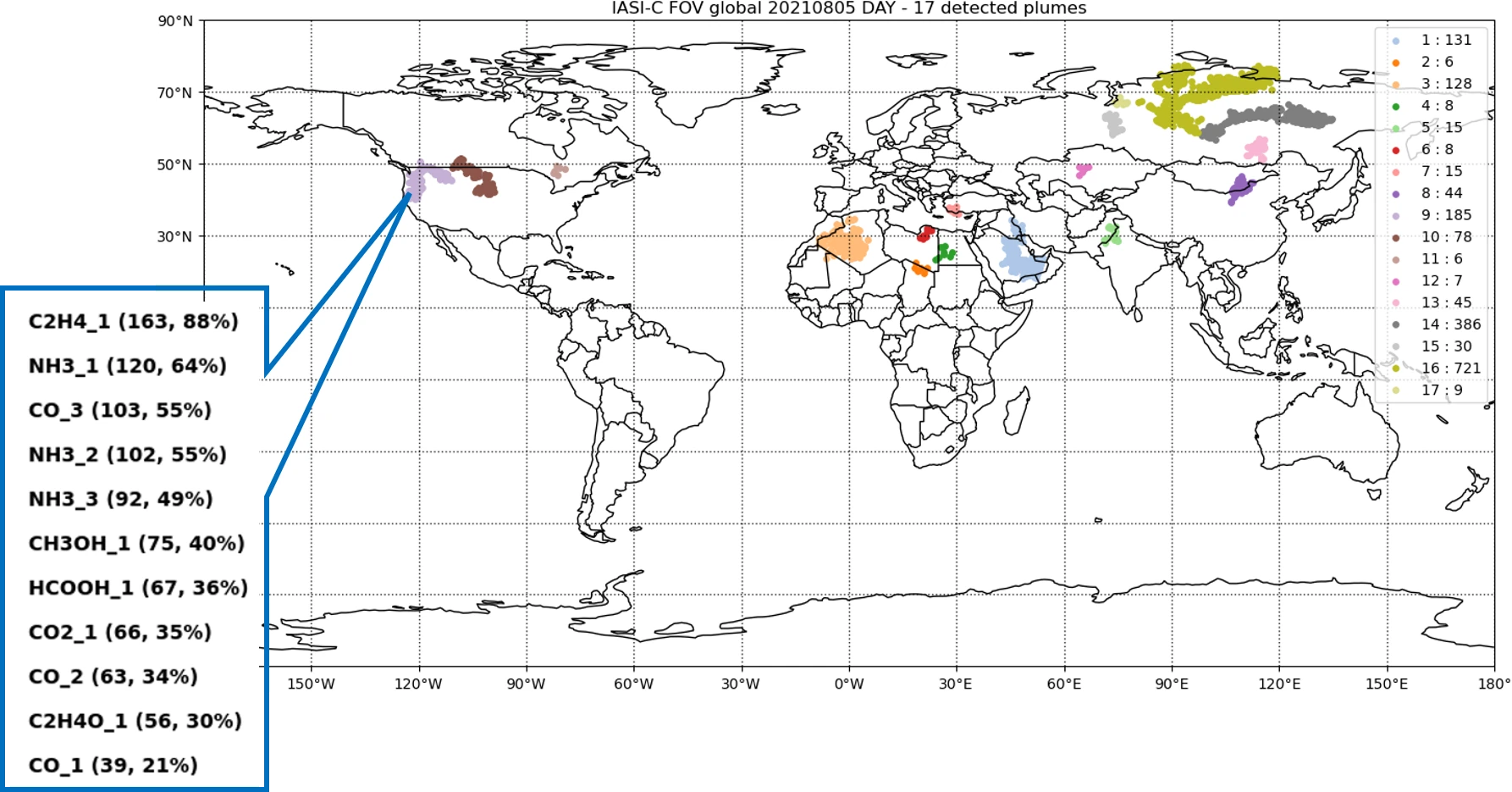
The methodology has been implemented in a software able to run in near-real-time conditions i.e. providing Level 3 products with a timeliness of 1 hour. The Level 3 products (example below) are defined as plumes or isolated events, according their most significant associated indicators, among the categories: “type 1 fires” (intense fires with at least CO_n and CO2_n indicators), “type 2 fires” (low temperature fires with at least C2H2_1, C2H4_1 and HCOOH_1 indicators), “fires” (more general category of fires), “volcanic eruptions” (with at least 3 SO2_n indicators) and “other events”.
The AERIS/ICARE data and service centre will operate the software and will disseminate the products through its data portal. The product release is expected in the course of 2025. Furthermore, a visualization tool will also be available to improve the user experience with the products.
In the perspective of the upcoming atmospheric sounding satellite missions, the combination of the IASI thermal infrared measurements and of the TROPOMI shortwave infrared observations has been analysed. Its great potential for the detection, characterisation and classification of extreme events such as fires and volcanoes has been demonstrated. So, using in synergy the data from the next atmospheric sounding missions on polar and geostationary orbits is very promising.

Example of global maps of Level 3 products, detected for a given day from IASI-C data.

