Sargassum monitoring from geostationary imagery

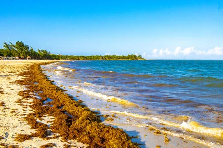
Since 2011, huge brown pelagic algae mass strandings (Sargassum fluitans and Sargassum natans) have occurred on the coasts of the Caribbean, Gulf of Mexico and West Africa. These sargassum landings affect drastically the coastal environment, cause devastating effects on human health and impact the economies of the tourism and fisheries industries. Satellite imagery allows to efficiently detect the presence and monitor the movements of floating sargassum.

Observations from sun-synchronous wide swath sensors, like Aqua/MODIS, Suomi-NPP/VIIRS or Sentinel-3/OLCI, and high spatial resolution sensors, like Sentinel-2/MSI or Landsat-8/OLI, are commonly used at basin and local scales. However, the observations from geostationary sensors are very valuable because, despite their reduced spatial resolution, they allow mitigating the daily cloud coverage and tracking the sargassum drift thanks to their high temporal resolution.

An operational method

Since 2020, HYGEOS has been developing a new software for processing GOES-16/ABI data at 1km of spatial resolution. The main advantage of this geostationary satellite is its capability to acquire one image every 10 minutes over a visibility circle centered on the 75° West meridian, thus covering the Atlantic Ocean from the Gulf of Mexico to the offshore of Western Africa. Consequently, the daily spatial coverage is improved by a factor 2 to 3, due to the daily movement of clouds, compared to one single acquisition. The sargassum index defined by HYGEOS is the Floating Algae Index (FAI) anomaly, which is the difference between the pixel FAI and a background FAI value of sargassum-free pixel. A detection of sargassum based on a threshold on the FAI anomaly is possible with pixel coverage of sargassum as low as 1.3%. The HYGEOS software is integrated in SAMTool, the operational Sargassum detection system operated by CLS.
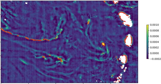
Daily composite of FAI anomaly derived from GOES-16/ABI image acquired at West of Martinique, and Sainte Lucia on 17th June 2022.

Daily composite of FAI anomaly derived from GOES-16/ABI image acquired at West of Martinique, and Sainte Lucia on 17th June 2022. Red lines delineate the detected sargassum.
A steadily improving detection

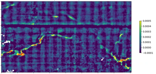
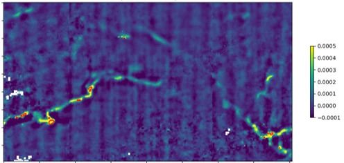
In the Sargassum Operational Detection Algorithms (SODA) project, which prepares an extension of the Copernicus Marine Monitoring Service, HYGEOS investigates the improvement of the sargassum detection with geostationary sensors. Indeed, on the above image, false sargassum detections appear near the coasts of islands, created by an increase of the FAI due to vegetation adjacency. The analysis of the variability of the FAI due to vegetation adjacency effect revealed a daily and seasonal variability. The strategy being implemented and tested is to derive pixel-by-pixel coastal correction map based upon a temporal median. Furthermore, GEOS-16/ABI has a significantly reduced radiometric performance, compared to other sensors like Sentinel-3 OLCI, and a major part of the processing chain is dedicated to denoising and performing radiometric corrections. Advanced methods are applied to perform a radiometric grid correction as illustrated on the figures below.

Daily composite of FAI anomaly derived from GOES-16/ABI image acquired on 19th March 2022 without radiometric grid correction.
Daily composite of FAI anomaly derived from GOES-16/ABI image acquired on 19th March 2022 with radiometric grid correction.

Daily composite of FAI anomaly derived from GOES-16/ABI image acquired on 19th March 2022, without (left) and with (right) radiometric grid correction.

Funder : CNES and Mercator Ocean International

Duration : 2020 – 2024

Contact at HYGEOS : François Steinmetz